CONFIRMED: Irma is now a hurricane
IN ONLY 10 MINUTES, tropical storm Irma went from 70 mph sustained winds, straight to 100 mph sustained winds. It was like an ambush, it was not supposed to intensify to hurricane until this week end!This is the type of anomaly I look for when determining if a storm is man made or not, this change was actually unnatural, and it is absolutely real, straight from NOAA SEE THIS it is real folks! 100 MPH sustained winds already??!!??
Hurricane Irma is impossibly far to the East to be as powerful as it is. The tropical depressions that become Atlantic hurricanes form off the west coast of Africa, and usually stay at either storm strength or remain depressions until they are at least twice as far off the African coast as Irma is now. This one could be a whopper. I doubt the sudden strengthening, which defied predictions, is natural. I still think Harvey was natural but am beginning to think they played with Harvey after landfall. This apparently will not be the case with Irma.
Look folks, Hurricane Irma is an impossible anomaly
If you live anywhere a hurricane can strike, now is going to be a good time to go out and get hurricane supplies, while they are cheap, BEFORE they run out.
Comb Craigslist or whatever other source to find used plywood so you don't have to pay an enormous price once your home is in the target zone. Get the minimum needed, so your home is not cluttered up with crap if it does not hit your area. Just get at least basic protection for as cheap as possible. NOW IS THE TIME TO ACT, Irma is clearly an anomaly, this happened WAY TO QUICK. I do not believe this one is natural AT ALL.
I MUST EMPHASIZE AGAIN: HURRICANE IRMA IS THE ULTIMATE WTF!
None of the news agencies have picked up on this yet, because it was such an ambush.Hurricane Irma was NEVER RECORDED AS A CATEGORY 1.
Irma jumped straight from practically nothing to a category 2 before anyone got a chance to measure it as a category 1. That's basically impossible, unless NOAA is lying, or someone flipped a switch somehwere and "turned on" a hurricane! I'd bet someone flipped a switch.Check out this storm tracking map, you can see here that Irma went from nothing of significance to a category 2 like someone simply flipped a switch!

Irma weakened, and then got stronger than ever before.
If Irma strengthens at the same rate it cumulatively did today, it will be a cat 4 early Sunday. The stronger Irma gets, the more Irma will determine it's own destiny, unless it is man made, then all bets on whatever happens are off.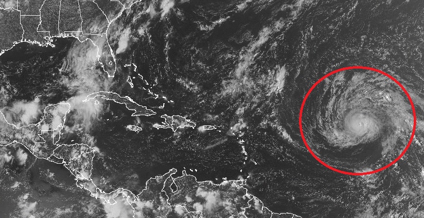
How did it go from probably tracking north to probably tracking along the route that will strengthen it the most possible, with a perfectly straight trajectory pointing right at Houston? Not plausible!
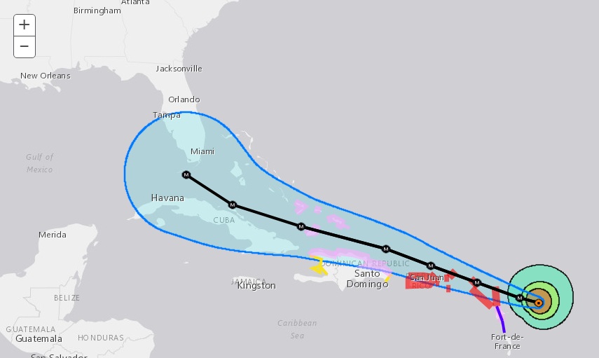
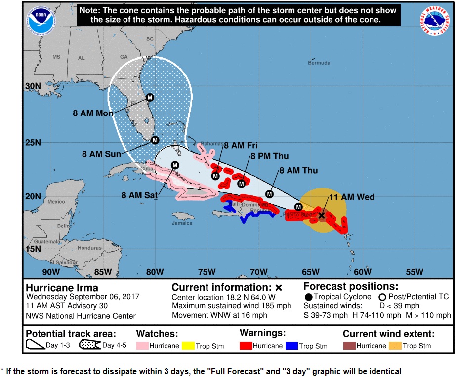
HERE IS YOUR TOTALLY RIDICULOUS LOGIC DEFYING TRAJECTORY CONE.
Louisiana and Texas are the most likely landfall zone....POTENTIALLY CATASTROPHIC CATEGORY 5 HURRICANE IRMA HEADING TOWARD THE LEEWARD ISLANDS... ...PREPARATIONS SHOULD BE NEARING COMPLETION IN THE EASTERNMOST LEEWARD ISLANDS...
Go to the latest USGS update and take a look. Irma has exceeded expectations. Obviously Irma could be natural because hurricanes like this happen, but I'm having my doubts.
The storm path is unbelievably perfect for max strengthening and destruction. Irma popped up out of nowhere from tropical storm straight to category 2 before anyone could take any in between measurements. And now the max sustained winds are 175 mph???!!! when I went to bed they were 132 mph. How did that happen overnight?There is no escaping a hard reality: It's gonna be BAD.
Ok, so let's say you are stuck in the damage path and you are south of the U.S. border. There is a cheap brand of tools in Mexico called Lion. They have awesome tape. Use their tape to tape your glass if you can't do anything else. Don't use scotch or any brand from wal mart. I confirmed with the CD's while mailing them that the clear packing tape from Lion is stronger and stickier than any other tape I have ever seen. That's for Mexico. In the U.S., you had better get going preparing, everyone pays attention to the max wind speed at the eye wall but if you are in a zone where the winds are 120 mph or less, you might get through this unscathed if you board up your windows NOW.
KEY POINT: Irma is getting SO NASTY that you won't have to be anywhere near a direct hit to have everything get ripped up. Don't just watch where the eye is going, even if it looks like you are not going to get a direct hit prepare anyway, Irma might be the storm of the century.
What will Irma do if it makes landfall with 200 plus MPH winds? Here's what: The grass in your yard will be gone. Tornado zones call this "scouring", where the storm is so bad it actually rips the earth up. This type of hurricane actually digs dirt. It strips off everything, there will be no trees. Wooden houses will look like an F5 tornado zone. Irma might be the type of storm that strips everything bare to the ground. Skyscrapers will handle it with broken windows. But even cinder block buildings will be blown over. Having a "brick house" won't cut it. Even if you are lucky enough to have a house made of solid concrete, the windows will be gone and there will be no place to hide from the wind as it rips through broken windows, throwing glass everywhere. Closing the bedroom door in the "one last safe room" probably won't work, because the wind coming through the windows will probably break the door.
Don't be a storm chaser with Irma, because you'll be dead. Unless something radically weakens Irma, you'll be dead if you stay where it makes landfall. It won't matter how good your observation area is.
Let's just hope I'm being doomy with this, but I'd bet I am not!
Remember: I call B.S. on fake hurricanes with good accuracy. I have done it 3 times now. There is absolutely no reason this time around to conclude Irma is fake. Irma may not be entirely natural, but it sure is not fake.
HURRICANE IRMA NOW A 185 MPH CAT 5
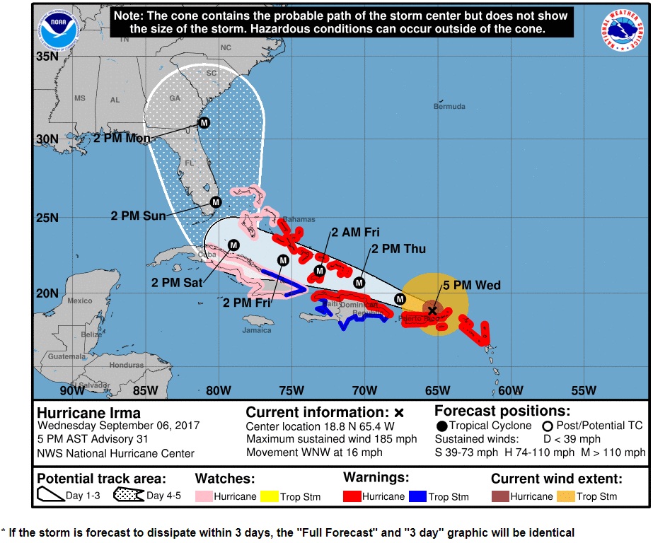
HERE IS the latest TRAJECTORY CONE.
It now looks like it will brush Florida and continue on into the gulf.HERE'S A REAL ODDITY:
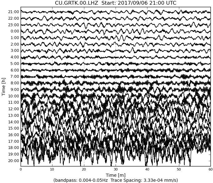
Hurricane Irma is registering on seismometers
Here's Irma on the Antigua/Barbuda Seismogram
IRMA KNOCKED THIS STATION OUT BEFORE THE EYE WALL PASSED.
That is why it went blank.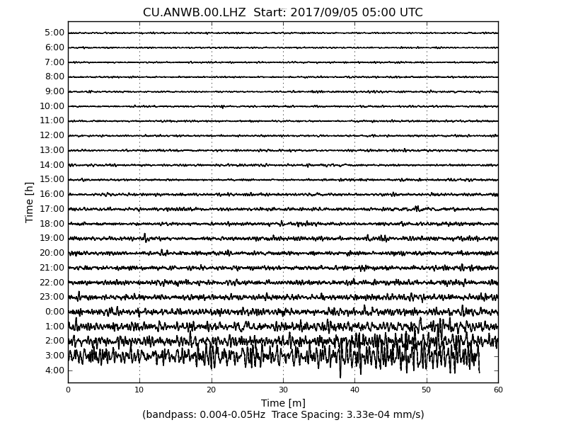
I have only this to say: If you are in the evacuation zone and are determined to stay where you are, Irma is making an ominous looking earthquake. That's something I never heard of before.
Hurricane Irma Advisory Number  30
NWS National Hurricane Center Miami FL       AL112017
1100 AM AST Wed Sep 06 2017

...EYE OF POTENTIALLY CATASTROPHIC CATEGORY 5 HURRICANE IRMA
CLOSING IN ON THE VIRGIN ISLANDS...


SUMMARY OF 1100 AM AST...1500 UTC...INFORMATION
-----------------------------------------------
LOCATION...18.2N 64.0W
ABOUT 65 MI...110 KM ESE OF ST. THOMAS
ABOUT 140 MI...225 KM E OF SAN JUAN PUERTO RICO
MAXIMUM SUSTAINED WINDS...185 MPH...295 KM/H
PRESENT MOVEMENT...WNW OR 285 DEGREES AT 16 MPH...26 KM/H
MINIMUM CENTRAL PRESSURE...918 MB...27.11 INCHES


WATCHES AND WARNINGS
--------------------
CHANGES WITH THIS ADVISORY:

A Hurricane Warning has been issued for the north coast of Haiti
from the northern border with the Dominican Republic to Le
Mole St. Nicholas.  A Tropical Storm Warning has been issued for
for the coast of Haiti from south of Le Mole St. Nicholas to
Port-Au-Prince.
Irma is obviously hurricane armageddon, but it is not a worldwide record setter by any means. Even a brief look at the topic pegs hurricane Allen as far larger, with a far lower barometric pressure and stronger winds, and hurricane Allen was not the worst. So when you read stories about how IRMA is the worst ever, keep in mind there are people after click bait who won't spend even 5 minutes to get their story straight.
Hate to be that blunt about it, and by all means if Irma is on it's way to you, GET OUT OF THE WAY, I am not saying Irma is anything
NWS National Hurricane Center Miami FL       AL112017
500 PM AST Wed Sep 06 2017

...EYE OF CATEGORY 5 HURRICANE IRMA MOVING AWAY FROM THE
NORTHERNMOST VIRGIN ISLANDS...
...TROPICAL STORM AND HURRICANE CONDITIONS SPREADING OVER PORTIONS
OF PUERTO RICO...

SUMMARY OF 500 PM AST...2100 UTC...INFORMATION
----------------------------------------------
LOCATION...18.8N 65.4W
ABOUT 40 MI...60 KM NW OF ST. THOMAS
ABOUT 55 MI...85 KM ENE OF SAN JUAN PUERTO RICO
MAXIMUM SUSTAINED WINDS...185 MPH...295 KM/H
PRESENT MOVEMENT...WNW OR 285 DEGREES AT 16 MPH...26 KM/H
MINIMUM CENTRAL PRESSURE...914 MB...26.99 INCHES

WATCHES AND WARNINGS
--------------------
CHANGES WITH THIS ADVISORY:

The government of the Bahamas has issued a Hurricane Warning for
the central Bahamas, including Cat Island, the Exumas, Long Island,
Rum Cay, and San Salvador.  A Hurricane Watch has been issued for
the northwestern Bahamas, including the Abacos, Andros Island,
Berry Islands, Bimini, Eleuthera, Grand Bahama Island, and New
Providence.

The government of Cuba has issued a Tropical Storm Warning for the
Cuban provinces of Guantanamo, Holguin, and Las Tunas.

The government of France has discontinued the Hurricane Warning for
Saint Martin and Saint Barthelemy
SUMMARY OF WATCHES AND WARNINGS IN EFFECT:

A Hurricane Warning is in effect for...
* British Virgin Islands
* U.S. Virgin Islands
* Puerto Rico, Vieques, and Culebra
* Dominican Republic from Cabo Engano to the northern border with
Haiti
* Haiti from the northern border with the Dominican Republic to Le
Mole St. Nicholas
* Southeastern Bahamas and the Turks and Caicos Islands
* Central Bahamas

A Hurricane Watch is in effect for...
* Cuba from Matanzas province eastward to Guantanamo province
* Northwestern Bahamas

Their tesimony of "over people's heads" can happen without anyone getting blown away, it all depends upon where the cars were when the wind picked them up, and how sheltered the area was where the people were.
Moral of the story: If you are in Irma's path and have more than one car, drive whatever you can out of there because you might lose it if you don't, people in Barbuda (numerous people) claimed to witness cars flying high in the air like litter in the wind. And oh, you are driving out of there, RIGHT???
NEW UPDATE to the below:
The second link did not put it in the right place either, even with coordinates. So zoom in on the globe and find the right spot. You'll see the fourth hurricane. INTERESTING NOTE: When you see the entire globe, the real action is happening between Africa and Antarctica, there is a WHOPPER going on down there that absolutely dwarfs Irma. But no one cares about that part of the world.UPDATE: The earth wind map link below did not zoom correctly.
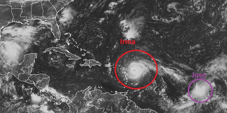
Click here if you can't find what I am talking about below and hopefully this link will work. The hurricane on the left hand side of the screen is Jose. The new development is in the lower right hand side.There is a FOURTH storm system developing behind hurricane Jose
Take a look at the winds in this Earth wind map. In the lower right hand corner, you can see a new probable future hurricane beginning to form. The rotation is obviously there. Very interesting map.THREE HURRICANES??!!??
Just a few hours ago there was one hurricane, a tropical storm, and a tropical depression. So I went online for the nightly post, and there are now 3 hurricanes??!!??Katia will be the one to watch. Katia is heading straight across super warm carribbean waters and will build strength faster than anything. I'd bet that by tomorrow (Thursday morning) Katia will be a category 3. Jose will not be as strong as Irma. Katia could easily become the strongest of the 4.
How do I know? EASY: Because hurricanes never hit record breaking levels without crossing the Carribbean, and Katia was born in the Carribean, is already a hurricane, is near shore, and headed out to sea. Carribean hurricanes are worse than Atlantic hurricanes. Irma is only record breaking in the Atlantic. Katia has a lot more heat to build with. The movements are perfect. Katia will be the worst.
What if I am wrong? Will I be guilty of a false prediction? ANSWER: Do you stop listening to the weather man after he screws up 900 times? I can be wrong about the weather once!
Tomorrow morning before 9 AM (or when the next subsequent NOAA update is given: Katia - winds between 95 and 110 mph. Before 6 PM: Katia, winds between 110 and 130 mph. I bet I am right!September 7
The global wind map is saying Katia is stronger than Jose
It is also saying that all 3 hurricanes are weaker than the USGS is reporting.
I could be right about Katia (my predictions last night.) Last night I said Katia would be category 3 by evening. If the global wind map is consistent, and the USGS numbers are accurate, Katia is in fact a category 2 and stronger than Jose right now, despite the latest USGS update (which lags badly). Go to the global wind map, get the hurricanes on screen and blow the map up all the way. Then click around the hurricanes to see what the wind speed is. Katia is in fact stronger than Jose. That would mean winds of 110 MPH or more in Katia, if the USGS numbers are actually correct on Jose, and the wind map is consistent.Additionally, Katia is doing what I said it would do, and NOT what the USGS said. Katia is in fact drifting north east, INTO the wide open waters of the Carribbean. It is going to get stronger than they are saying right now.
There are 7 nuclear reactors direcly in the path of Irma
The first to get hit will be Turkey Point, which has two 700 megawatt reactors. It is on the southern tip of Florida, directly in the path of the eye with the current forecast cone.
The second to get hit will be St Lucie nuclear power, which has 2 1.002 gigawatt reactors. This is also directly in the path of the eye, while the eye is still strong.
The third to get hit will be the a training reactor in Gainesville Florida.it is rated at 100 kilowatts which means it is not a toy. It is obviously smaller than the other two, but could still make a mess. Many training reactors only have 100 watts total potential, which means the one in Gainesville is quite large for what it is.
The fourth to get hit will be Vogtle nuclear in Georgia. It has two 1.2 gigawatt reactors. Irma will probably still be a category 3 when it hits, but I would not expect much to happen.
All the nuclear power facilities are designed to withstand hurricanes, so I'd say there is nothing to worry about OTHER THAN STUXNET. Let's hope no one has plans to use the hurricane as cover for anything
Another station Grand Turk and Caico Islands registers approach or Ground Zero of Irma:
...EYE OF EXTREMELY DANGEROUS HURRICANE IRMA MOVING BETWEEN
THE NORTH COAST OF HISPANIOLA AND THE TURKS AND CAICOS ISLANDS...


SUMMARY OF 200 PM AST...1800 UTC...INFORMATION
----------------------------------------------
LOCATION...20.7N 70.4W
ABOUT 65 MI...105 KM NNE OF PUERTO PLATA DOMINICAN REPUBLIC
ABOUT 70 MI...115 KM SE OF GRAND TURK ISLAND
MAXIMUM SUSTAINED WINDS...175 MPH...280 KM/H
PRESENT MOVEMENT...WNW OR 290 DEGREES AT 16 MPH...26 KM/H
MINIMUM CENTRAL PRESSURE...922 MB...27.23 INCHES


WATCHES AND WARNINGS
--------------------
CHANGES WITH THIS ADVISORY:

None.

SUMMARY OF WATCHES AND WARNINGS IN EFFECT:

A Storm Surge Watch is in effect for...
* Jupiter Inlet southward around the Florida peninsula to Bonita
Beach
* Florida Keys

A Hurricane Warning is in effect for...
* Dominican Republic from Cabo Engano to the northern border with
Haiti
* Haiti from the northern border with the Dominican Republic to Le
Mole St. Nicholas
* Southeastern Bahamas and the Turks and Caicos Islands
* Central Bahamas
* Northwestern Bahamas

A Hurricane Watch is in effect for...
* Jupiter Inlet southward around the Florida peninsula to Bonita
Beach
* Florida Keys
* Lake Okeechobee
* Florida Bay
* Cuba from Matanzas province eastward to Guantanamo province


